-
Bicycle Master Plan update
Open for commentComments close Nov 30: Draft Bicycle Master Plan
The City is rewriting its 2013 Bicycle Master Plan. It released the draft plan on October 16, 2026. The draft shows 2,025 miles of bikeways across the city, including more than 600 miles of planned separated bikeways (bike lanes set apart from car traffic).
The City says adopting the plan will not require it to build or fund any project now. Each project would get more review and be built as funding allows.
On the City's draft map, Serra Mesa gets one-way separated bikeways on Murray Ridge Road, Genesee Avenue, Mesa College Drive and a short piece of Kearny Villa Road.
It also gets bike boulevards on Afton Road, Hurlbut Street, Berger Avenue, Health Center Drive, Birmingham Way, and the Birdland streets Meadow Lark Drive, Starling Drive, Cardinal Road and Cardinal Drive. A bike boulevard can add traffic calming, such as speed cushions, traffic circles or curb extensions.
The separated bikeways planned on Ruffin Road are north of Aero Drive, in Kearny Mesa. The map shows no change to Ruffin Road's existing bike lanes in Serra Mesa.
Next: You can comment on the draft plan from October 16 to November 30, 2026. Use the comment form on the City's project page, or email mobility@sandiego.gov.
After that, the City plans to present the draft plan to the City Council's Active Transportation and Infrastructure Committee. No date is set. This comes from a City list of climate-action milestones prepared for the Climate Advisory Board's October 6, 2026 meeting. The City Council decides whether to adopt the plan.
Planning group: The planning group discussed the draft network on April 16, 2026. There is no process for a community group to comment. So members agreed that people can answer the survey on their own.
The planning group lists the draft plan as a future agenda item.
The community council's November–December 2026 newsletter goes through the Serra Mesa streets in the draft. It says Murray Ridge Road would need to be reconfigured to fit a separated bikeway. It asks whether one fits on the Murray Ridge bridge, which Caltrans controls. And it says emergency access and the single way in and out of Birdland should be dealt with before any bike boulevard changes there.
The newsletter also reports an October vote by the Community Planning Committee, made up of representatives of each planning group. The committee voted to comment on the lack of maintenance on existing separated bike lanes, such as on Aero Drive.
- Presentation to the City's Mobility Board
- Planning group minutes
- Plan summary for Serra Mesa
- City climate-action milestones (Climate Advisory Board)
- Draft Bicycle Master Plan
- Community council newsletter on the draft (pages 6–8)
- Expected:Comment period closes
Updated · More on this project →
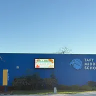
Taft Middle School pick-up and drop-off
Under reviewOn October 19 the school district held a follow-up meeting. The school, district police, the councilmember's office, the planning group and the community council took part.
The district's summary says opening other pick-up and drop-off areas, including Lot B, has helped. But some problems remain, mostly in the ten minutes of afternoon pick-up: double parking, U-turns, left turns, blocked bike lanes and too little driveway space.
The HAWK crossing signal on Gramercy Drive has qualified for installation and is waiting for funding. A HAWK signal is a pedestrian signal that stops traffic only when someone pushes the button to cross.
Next: The next meeting with the school district is planned for January 2027.
The agreed next steps are to look at traffic calming, such as concrete medians, and other pick-up layouts; get more traffic help at dismissal; keep enforcing parking rules in the pick-up zones; and find funding for pedestrian safety work.
The City and the district also mentioned repainting curbs, widening the driveway and adding sidewalk signs.
After the meeting, some attendees discussed adding parking in front of the school by removing red curb that buses no longer need. The councilmember's office said it would look into parking limits at set times in the Ruffin Road cul-de-sac.
Planning group: The planning group wrote to the district on May 21, 2026. It raised four problems: cars double parking in the Gramercy Drive bike lane, illegal U-turns, parking in the center turn lane, and students crossing where there is no crosswalk.
In November 2025 the councilmember's office had reported that the district was against a HAWK crosswalk.
- Planning group minutes
- Planning group letter
- Planning group minutes
- Meeting report in the Observer
- Planning group minutes
- Follow-up meeting summary (Observer, page 9)
- Expected:Next meeting with the school district
Updated · More on this project →
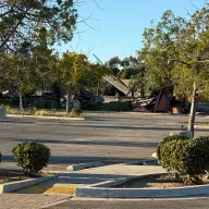
KB Home wants to build 199 townhomes for sale on about nine acres. They would be in 27 buildings, all three stories tall. Of the 199 homes, 70 have two bedrooms, 99 have three and 30 have four. Every home has a garage, and there are 57 parking spaces for guests.
Eight of the homes, in two buildings, are "shopkeeper units." The person who lives there can run a shop on the ground floor. The shops add up to 14,669 square feet. The City's draft conditions call these commercial condominium units. KB Home has asked the City to call them homes instead.
The site would have two driveways. One opens onto Ruffin Road. The other opens onto Gramercy Drive, where a new raised median would let drivers turn right in and right out only.
Next: City staff will decide whether to approve the project. The City calls this Process 1: there is no public hearing, and you cannot appeal the decision. The City has not said when it will decide.
KB Home applied on May 14, 2025 (project number PRJ-1136506). Since then it has sent the City four rounds of plans. In its latest review comments, dated October 7, 2026, the City closed every review except traffic. The open traffic items are the lane markings for the new median, the sidewalk connections, how far drivers can see at the driveways, and KB Home's requests to skip the City's rules on motorcycle parking and loading zones.
Planning group: On August 20, 2026, the planning group voted 7–0 to write to the Mayor. The letter asked three questions. How can a project this large go ahead without community input? What happened to the $500,000 that a 2004 permit for the site, called Mission Village, set aside? And who will clear the burned Guild Mortgage building?
The Mayor's office replied that the City never collected the $500,000 because the 2004 project was never built. So neither the money nor the community room that project promised carries over to KB Home.
The planning group then posted a letter from February 2007. In it, the City agreed that the 2004 permit had been used, because a parcel map was recorded in 2005. Under the Municipal Code, a permit counts as used once a parcel map tied to it is approved. A used permit stays in force unless the owner asks the City to cancel it. The group's chair is sending the Mayor a second letter about design, public improvements and the process.
The burned building is a total loss. The City opened a code enforcement case (CE-0542361) on July 9, 2026. On August 10 it ordered the owner to clean, board up and secure the property. The owner is waiting for the County to approve asbestos clearance before removing the debris. The City's Development Services Department planned to ask the contractor for a demolition date in the first week of November. These updates come from the Mayor's office, through the community council's November–December 2026 newsletter. No date for clearing the site has been published.
KB Home's filings call this an affordable housing density bonus project. Under state law, a builder that includes some affordable homes can ask to skip some City rules, and KB Home has asked. None of the released files says how many homes would be affordable. KB Home's affordable housing checklist is blank. A note on it says KB Home will fill it in later, and no completed copy is among the released files.
- 2007 letter on the 2004 permit, countersigned by the City
- KB Home's application to the City (PRJ-1136506)
- Affordable housing checklist, left for a later submittal
- Site plan and unit mix (in KB Home's water study)
- Planning group letter to the Mayor
- Mayor's office reply
- Planning group minutes
- City review comments, all reviews
- Mayor's office update on the burned building (newsletter, page 10)
All files from the records request (26-10406)How Process 1 works (Municipal Code)When a permit counts as used (Municipal Code)Updated · More on this project →
-
Smoke shop alcohol license (3355 Sandrock Rd)
Under reviewThe owners of the smoke shop at 3355 Sandrock Rd have applied for a Conditional Use Permit. A Conditional Use Permit allows a use only under conditions the City sets. This one would let the shop sell beer, wine and spirits to take away (a Type 21 license).
The 0.03-acre site is zoned CN-1-2 (neighborhood commercial). It lies inside Montgomery Field's airport influence area, the area around the airport where extra land-use rules apply. The state license application for this address has been pending with the Department of Alcoholic Beverage Control since September 2024.
The police recommend approval with two limits. Sales would be allowed only from 6 a.m. to midnight. Tobacco products could take up no more than 10 percent of the shop.
The police report notes three things. The census tract already has the two off-sale licenses (licenses to sell alcohol to take away) its population allows. The shop is within 100 feet of homes. And after an August site visit, police issued the shop a notice of violation for selling flavored nicotine products. A follow-up check found them removed.
Next: The City's Hearing Officer will decide at a public hearing, where anyone can speak. The City calls this Process 3. The City will mail a separate notice with the hearing date.
The project is going through environmental review. In November 2026 the City's permit data showed the application waiting for corrections from the applicant.
The planning group had planned to discuss it on October 15, but that meeting was cancelled. Its November/December newsletter lists the application as a future agenda item. No November agenda had been posted by November 6.
- Police recommendation
- City notice of application
- Planning group minutes
- Community council newsletter, planning group future agenda items (page 6)
City permit record (PRJ-1157548)State license record (ABC license 662781)City development permits dataUpdated · More on this project →
-
Children's Way cul-de-sac (street vacation)
Under reviewAn application asks the City to give up the 0.17-acre cul-de-sac at the end of Children's Way, east of 8105 Birmingham Way on the hospital campus. The City calls this a street vacation: the street would stop being a public street. The City lists 8105 Birmingham Way as one of the addresses of the Rady Children's Hospital main campus.
The City's notice of application, dated September 10, 2026, says the site is in the CO-1-2 zone. It also says the project is going through environmental review.
Next: The City Council will decide at a public hearing, where anyone can speak. The City calls this Process 5. The notice says the City will mail a second notice with the hearing's date, time and place.
No hearing date has been published. The City's permit record shows the application is waiting for the applicant to send revised plans ("recheck required").
Planning group: The planning group has not taken a position. Its September 17, 2026 minutes say a member will follow up on it. Its November–December 2026 newsletter lists the application as a future agenda item.
- City notice of application
- Planning group minutes
- Planning group lists it as a future agenda item (newsletter, page 6)
City staff report listing Rady campus addressesCity permit record (PRJ-1159819)How decision processes work (Municipal Code)Updated · More on this project →
-
San Diego Unified plans 108 apartments for district employees. 107 of them would be affordable. They would go on the north parking lot and the undeveloped land at the district's Instructional Media Center in Birdland. Decro Corporation is the developer.
Decro proposes a 99-year ground lease: the district keeps the land and rents it to Decro. The district estimates it would receive $51.8 million in ground rent over that time, and it would not have to spend any district money.
On December 10, 2025, the school board told district staff to study the site in detail and negotiate final terms with Decro. On June 23, 2026, the board let Decro onto the site for its studies. It also approved agreements for Decro to pay the district's environmental review costs.
Next: The district says it must finish the environmental review before it can approve and build the project. An independent financial analysis is due in November 2026.
Planning group: In March 2026 the planning group was told the district will present the project when it is ready.
The planning group lists the project as a future agenda item in the November–December 2026 newsletter. It has not set a meeting date for it.
- School board advances the Decro proposal (district news)
- Site and unit count (10News)
- Planning group minutes
- District update in the Observer
- Planning group lists it as a future agenda item (newsletter, page 6)
- Expected:Independent financial analysis due
Updated · More on this project →
-
Montgomery Field airport master plan
Under reviewThe master plan sets out 20 years of development at the 550-acre airport north of Aero Dr. It proposes 92 new hangars, 48 tie-down spaces (outdoor spots where planes are parked and tied down), a 6,400-square-foot terminal expansion, a public viewing area and an unleaded fuel tank.
On the airfield, the plan would remove the displaced landing threshold on Runway 28R. A displaced threshold is a landing point set back from the end of the runway. The plan would also add approach lighting and reconfigure several taxiways.
The draft environmental report found effects on biological resources and land use that cannot be fully mitigated (reduced or offset). It found aircraft noise less than significant.
In October 2026 inewsource reported that the airport emits more lead than any other general aviation airport in the country. It found that the master plan's own figures, based on a 2017 study, put the airport above the level at which the EPA usually requires local air monitoring. It also found that no lead sampling has been done there.
Next: The City Council will decide whether to certify the final environmental report, and will approve the master plan at the same time. No date has been published. The final report will respond to the comments.
In July 2026 the City's draft responses to comments were with the City Attorney's Office. In September Airports staff were meeting weekly with the consultant and City Planning on updates to the report. In October they reported meeting internally on the report's status and discussing a possible schedule.
Planning group: The planning group asked for 14 more days to comment and got them. The City's Chief of Airports presented to the planning group on November 20, 2025. After that, the group had its chair send a comment letter.
The community council and the Montgomery-Gibbs Community Committee sent letters of their own. The committee opposed removing the displaced threshold and expanding the terminal.
The objection is an old one. The 1977 community plan noted fears that a longer Runway 28R would bring "larger (and noisier) aircraft". It put on record that "any increase in aircraft noise levels will not be tolerated."
- 1977 community plan (Montgomery Field, pp. 78–81)
- Notice of Availability
- Planning group request for more time
- Planning group minutes (airport presentation)
- Planning group letter
- Community council letter
- Montgomery-Gibbs Community Committee letter
- Airports Advisory Committee status report
- Airports Advisory Committee agenda, with the master plan status
- Airports Advisory Committee agenda, October status report
- Worst lead polluter among general aviation airports (inewsource)
Updated · More on this project →
-
Rady Children's has applied to build a mental and behavioral health building at 3020 Children's Way. It would be four stories and 98,000 square feet. It would have 48 beds for patients aged 4 to 18, and a secured, landscaped outdoor space.
A January 2026 trade report describes what the building adds. It doubles Rady's inpatient capacity from 24 rooms to 48. It grows emergency psychiatric space from 6 beds to 24. It adds outpatient programs for about 70 young people a day. The report says the building would open in late 2028 or early 2029.
Rady told the planning group that construction workers have been told not to park in residential areas.
Next: The City Council will make the final decision at a public hearing. The City calls this Process 5. The application also asks the City to give up part of Birmingham Way.
In November 2026 the City's permit data showed the application waiting for corrections from the applicant. No hearing date has been published.
Planning group: The planning group voted unanimously to support the project on October 16, 2025.
- Planning group minutes
- Rady to double behavioral health capacity (OPEN MINDS)
- Expected:Rady expects to finish the building
City permit record (PRJ-1141068)City development permits dataHow decision processes work (Municipal Code)Updated · More on this project →
-
The San Diego Housing Commission bought this 90-unit building, a former short-term rental, on April 10, 2026. The approved price was up to $37.35 million.
The Housing Commission is turning it into 80 apartments with support services, plus two units for managers. The apartments are for people earning up to 30 percent of the area median income. Forty are for veterans who have been homeless. Twenty are for people who have been homeless for a long time, and 20 are for people at risk of homelessness.
A 55-year covenant, a legal promise tied to the property, keeps the 80 units affordable. State Homekey+, City and County money pays for it.
On July 9 the Housing Commission board voted 4-0 for a construction contract with LDCo., Inc. of up to $3,581,600. The work turns eight units into offices and a common room for residents. It replaces the roof, and adds cameras, gates, lighting and accessibility upgrades. The state grant sets December 14, 2026 as the date the work must be finished.
Planning group: The Housing Commission presented the project to the planning group on August 21, 2025. The group took no vote.
- Planning group minutes
- Housing Commission funding and purchase approval
- Housing Commission report on the construction contract
- Housing Commission vote on the contract (minutes)
- Expected:Completion date set by the state grant
Updated · More on this project →
-
The City approved a Conditional Use Permit for the market and gas station at 3377 Sandrock Rd. A Conditional Use Permit allows a use only under conditions the City sets. This one lets the 1,531-square-foot store sell beer, wine and spirits to take away (a Type 21 license). The owner and applicant is Murad Enterprises, LLC. The permit does not include any building changes.
The police supported the permit and recommended conditions. Sales are allowed only from 6 a.m. to midnight. Video must be kept for at least 30 days. Litter and graffiti must be removed promptly. Staff must be trained on alcohol rules.
City staff found no homes within 100 feet, and no schools, parks or other sensitive uses within 600 feet. They found crime in the census tract was below the citywide average.
The Hearing Officer approved it on consent, as a routine item. The owner and a representative spoke in favor.
The state issued the Type 21 license on July 6, 2026, and it is active. Under the license, sales are limited to 6 a.m. to midnight, beer is sold only in multi-packs, and spirits can't be sold in bottles smaller than 375 ml.
Planning group: The planning group voted 5–2 on July 17, 2025 to recommend approval.
Updated · More on this project →
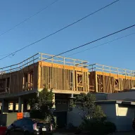
Community HousingWorks is building a five-story building over a 22-space garage. It will have 59 affordable apartments and one unit for the manager. Of the apartments, 56 have one bedroom and four have two bedrooms.
Thirty apartments are for veterans who have experienced homelessness. The VA refers them.
Rents stay affordable for 55 years. They are for households earning 30 to 60 percent of the area median income. The developer leases the land from the City for 65 years.
Next: The builder plans to frame the third and fourth floors in December 2026 and January 2027. The outside finishes and the roof come next, from January to July 2027. Landscaping and street work follow in August and September 2027. People are planned to move in from October to December 2027.
Community HousingWorks says the waitlist is coming soon. You can apply for the general affordable apartments about 120 days before the City clears the building for people to live in. Applicants go through a background check.
Planning group: The planning group and the community council sent the City Council a joint letter. It was about the building's height, parking, and how the review was handled.
The district's councilmember said he found no legal or policy grounds to deny the project.
- Project background
- Joint letter to the City Council
- Construction start (KPBS)
- Groundbreaking (Housing Commission)
- Builder's update to the community council
- Builder's answers to community questions (Observer, page 11)
- Expected:Applications open for the general affordable apartments, about 120 days before move-in (veterans' units are filled by VA referral)
- Expected:Move-ins
Updated · More on this project →
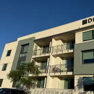
CityMark is replacing a one-story office building with 60 homes. The site is the 1.72-acre corner of Mission Village Drive and Ruffin Road. There are 25 townhomes in seven buildings at 3303–3315 Ruffin Road, and a building with 35 apartments. Three of the apartments are for very-low-income households.
City staff approved the homes without a hearing (PRJ-1079662). CityMark used an affordable-housing density bonus, which raised the limit from 50 to 60 homes. A density bonus is a state rule that lets a builder add homes when some of them are affordable.
The Hearing Officer also approved a map waiver, which lets CityMark sell the townhomes as condominiums. The same decision excused CityMark from moving the overhead lines on Marathon Drive underground. It was approved on consent, as a routine item, and no one spoke.
CityMark sells the townhomes as Dezi. In June 2026 the townhomes were priced from about $980,000 to $1,060,000. Another apartment building was still being built then. The community council's November–December 2026 newsletter said construction was almost complete.
Planning group: The planning group voted 6–0–1 on April 17, 2025 to recommend approval.
- CityMark presents its three Mission Village Dr projects to the planning group (newsletter, page 16)
- Notice of application for the map waiver
- Planning group minutes
- Hearing Officer report
- Hearing Officer minutes
- San Diego Business Journal
- Construction almost complete (newsletter, page 28)
Updated · More on this project →
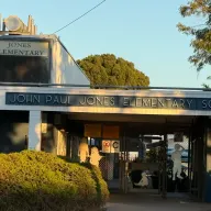
San Diego Unified and the City are turning the field at Jones Elementary into a joint-use park. The school uses it during school hours, and the public can use it outside school hours. It is part of the City's Play All Day program.
The park would have a 2.09-acre natural grass field with a 9-foot asphalt walking track around it. It would also have shade trees, a drinking fountain, fencing and an accessible parking lot.
The school district leads the design and construction. It pays for them with bonds that voters approved.
Next: The school district will build the field as part of a modernization of the whole Jones Elementary campus. The work also adds a new administration building and a student drop-off area. The district's construction portal schedules the work from November 2027 to January 2030.
Planning group: The planning group voted 6–0 on August 15, 2024 to recommend the park plan.
- Environmental determination (City)
- Parks and Recreation Board report
- Park plan approval (City)
- Expected:Construction starts
- Expected:Construction finishes
Updated · More on this project →
-
Sharp Memorial McGrath Tower
ApprovedSharp is adding a hospital tower, named the McGrath Tower, at 7901 Frost St. It has seven levels and 260,000 square feet. Sharp is also adding a six-level, 95,000-square-foot expansion of the Sharp Mary Birch building.
The eight-level central and south towers will be cut down to their second-level base. The Knollwood Building will be replaced by a 120,000-square-foot office building.
The campus ends up with 113 fewer beds. The new tower has 152 beds and the Mary Birch expansion has 27, while 256 are removed from the older towers. The new tower can reach 122 to 139 feet. The zone limit is 60 feet.
The City Council approved the permits 9–0 on July 24, 2023. It also approved a small street vacation on Birmingham Way, which means that piece stops being a public street.
In January 2026 Sharp's builder reported that a new central energy plant was finished. This was an early phase of the campus plan. Sharp says the tower will open in 2030. The City's environmental review says all parts of the work would be finished in 2031.
- City environmental review (addendum)
- City Council minutes (Item 204)
- Environmental filing (CEQAnet)
- The McGrath Tower (Sharp)
- New central energy plant finished (Construction Owners)
- Expected:McGrath Tower opens
- Expected:All construction finishes
Updated · More on this project →
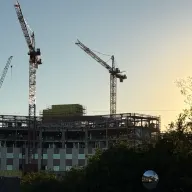
Rady Children's is building a seven-story, 486,000-square-foot pavilion at the southwest corner of Frost Street and Children's Way. It is for pediatric, newborn and heart intensive care, emergency and trauma care, and operating rooms.
It has 140 beds: 126 moved from elsewhere on the campus and 14 new. In 2026 Rady said the seventh floor, first planned as empty space, will get 40 more intensive care beds, for 180 in all. The second floor will hold an imaging center.
Most of the building is 140 feet tall. It rises to 175 feet at the rooftop helipad. The project also adds a 36,000-square-foot utility plant and a 33,500-square-foot connector building. It removes about 76,450 square feet of older buildings. The Planning Commission approved it 5–0 on May 18, 2023.
Rady told the state it expects to finish construction in December 2027 and move patients in by April 2028. Construction costs about $1.4 billion.
In January 2026 the state health facilities financing authority approved a grant of up to $135 million for the pavilion. It also approved up to $820 million in bonds, of which $598 million goes to building it.
Planning group: The planning group voted 7–2 on November 17, 2022 to recommend the project with no conditions.
- Planning Commission staff report
- Planning Commission minutes
- Groundbreaking (Rady Children's)
- State financing authority staff report
- State financing authority minutes
- Steel frame finished; 40 beds added (San Diego Business Journal)
- Expected:Construction finishes
- Expected:Patients move in
Updated · More on this project →
-
The City approved a four-lane road with bike lanes from Phyllis Place south to Via Alta and Franklin Ridge Road in Civita. It has not been built.
The approval also requires two other changes. Phyllis Place must be widened to five lanes with bike lanes between the new road and I-805. And the Murray Ridge Road bridge over I-805 must be restriped to five lanes with two bike lanes. The legal challenge ended in March 2022, when the California Supreme Court declined to hear the case.
Caltrans is responsible for the bridge. In 2023 it drafted a different layout, with four lanes and two separated bikeways. The community council's November/December 2026 newsletter says the developer has submitted a design for the approved five lanes and two bike lanes on the bridge.
The City's draft Bicycle Master Plan is open for comment until November 30, 2026. It shows separated one-way bikeways planned on Murray Ridge Road, and on Phyllis Place between the bridge and Franklin Ridge Road.
The City is reviewing two applications. The first is a grading and public improvements permit, applied for in September 2026 (PRJ-1166343). Grading means moving earth to shape the land. The permit would widen Phyllis Place, extend Franklin Ridge Road, add a traffic signal, and restripe the bridge. The second is a final map for Phyllis Place and Franklin Ridge Road (PRJ-1164349), in review since August 2026. A final map is the map that legally divides land into lots.
The newsletter still lists the schedule for the road and its mitigations (the steps required to reduce its effects) as pending. In July 2025 the planning group was told the project was waiting for SDG&E to raise a gas line.
Planning group: The planning group and the community council opposed the road during the environmental review, and then in court.
The City Council approved it on October 30, 2017. The Superior Court and the Court of Appeal both ruled for the City. On March 16, 2022, the California Supreme Court declined to hear the case.
- Planning group response to the draft EIR
- Council resolution R-311380 (environmental report and mitigations)
- Council resolution R-311381
- Court of Appeal opinion
- Supreme Court petition conference
- Community council newsletter on the Murray Ridge bridge (page 10)
- Planning group minutes
- Community council newsletter, project list
- Community council newsletter, bridge design and bike plan (pages 7 and 28)
Updated · More on this project →
-
The City Transportation Department's plans for lane markings, signs and signals cover Mission Village Drive from Friars Road to Gramercy Drive. They add buffered bike lanes, which have a painted strip between the bike lane and car traffic. The bike lanes run 1.15 miles northbound and 0.76 miles southbound.
From Friars Road to Ronda Avenue, the northbound side narrows from two lanes to one. From Ronda Avenue to Ruffin Road, the street goes from four travel lanes to one lane each way with a center turn lane.
The community council's newsletter reported in its September/October 2023 issue that the Ronda-to-Ruffin narrowing was finished.
Planning group: The planning group wrote to the councilmember and the Transportation Department in August 2022. It said it had little notice of the plans. It said the traffic study used 2016 counts from before Snapdragon Stadium. And it said the 40 mph speed limit was unchanged.
In October 2023 the planning group wrote to the Mayor. It said the City made the change without consulting the community. It said the change had caused backups on Ruffin Road to Success Avenue at peak times.
The community council also opposed the narrowing.
- Design drawings
- Planning group letter
- Community council newsletter on the reconfiguration (page 13)
- Community council newsletter, narrowing finished (page 3)
- Planning group letter to the Mayor
Updated · More on this project →


